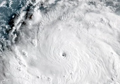


Hurricane Erin, the first hurricane of the 2025 Atlantic season, was downgraded to a Category 3 storm on Sunday, according to the United States National Hurricane Center (NHC).
The storm, located 330 miles (530 km) southeast of Grand Turk Island, carries maximum sustained winds of 125 mph (205 kph).
It is moving west-northwest at 14 mph (22 kph), with a expected slowdown and a turn northward by Monday or Tuesday.
Erin, the fifth named storm of the season, had briefly reached Category 5 status before weakening.
The NHC reported that swells from Erin will affect the northern Leeward Islands, Virgin Islands, Puerto Rico, Hispaniola, and the Turks and Caicos Islands over the next few days.
These swells are expected to spread to the Bahamas, Bermuda, the U.S. east coast, and Atlantic Canada early to mid-week.
Rough ocean conditions may cause life-threatening surf and rip currents.
A tropical storm warning is in effect for the Turks and Caicos Islands, with heavy rainfall of 3 to 6 inches (7.6 to 15 cm), and up to 8 inches (20 cm) in isolated areas, expected in the Virgin Islands and Puerto Rico.
The Bahamas has also issued a tropical storm watch for its southeast regions.
In response, the U.S. government has deployed over 200 Federal Emergency Management Agency personnel, and Puerto Rico has prepared 367 shelters, as confirmed by Housing Secretary Ciary Perez Pena.
The Bahamas is readying shelters and advising residents to stay informed.
Power outages affected over 159,000 customers in Puerto Rico on Sunday, according to Luma Energy.
Scientists note that climate change, by increasing ocean temperatures and atmospheric water vapor, contributes to the rapid intensification of Atlantic hurricanes, complicating forecasting and emergency planning.
The Atlantic hurricane season, spanning June 1 to November 30, is projected to see six to ten hurricanes, with three to five potentially reaching major status.